EN

Translate:

Policy recommendations going to April 13 Council Meeting

  • Home
  • Focus Areas
  • Events & News
  • FAQ
  • OpenHouse
  • More
    • Home
    • Focus Areas
    • Events & News
    • FAQ
    • OpenHouse
  • Sign In

  • My Account
  • Signed in as:

  • filler@godaddy.com


  • My Account
  • Sign out

EN

Signed in as:

filler@godaddy.com

  • Home
  • Focus Areas
  • Events & News
  • FAQ
  • OpenHouse

Account


  • My Account
  • Sign out


  • Sign In
  • My Account

Lake Street Route

Welcome

The Lake Street cycling route is 2.30 kilometres long and is located between Placid Avenue and Queen Street. 


Due to the relative narrowness of the street, the route will largely consist of dedicated cycle lanes that are 1.5 metres wide, inclusive of a 0.5 metre wide painted buffer. Between Wellington Street and Queen Street, "bike route" signs instead of painted lanes will be implemented.


 The hill will benefit from a wider 1.8 m wide cycle route. Shared lanes are being proposed near several intersections, including McNabb Street, MacDonald Avenue, and Trunk Road. 


Many community amenities and key locations are near or directly connected to this route, including Bellevue Park, John Rhodes Community Centre, Churchill Plaza, Ben R. McMullin Public School, River View Public School,  Anna McCrea Public School, Algoma University, Forest Glen Park, Sunrise Ridge Park, Retta Park and Finn Hill.


The proposed route also connects to the Hub Trail, the Queen Street cycle route, and the proposed MacDonald Avenue cycle route.


 ★   Project contact details are at the bottom of this page  ★


Selecting the Cycling Facility

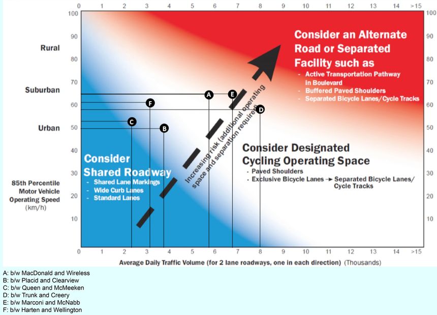
The nomograph shown above, is one of the many resources that helps guide the selection of a suitable design by factoring in vehicular speed and traffic volumes.


Traffic data captured at various locations suggests that dedicated bicycle lanes and shared lanes in some areas are appropriate for Lake Street. These locations are identified as A, B, C, D, E and F on the nomograph.

Route Styles

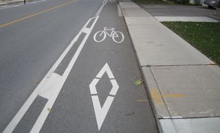
Dedicated bike routes that are marked with paint and separated from the roadway are appropriate for streets with higher vehicular traffic speeds and volume.

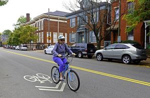
A shared lane may be appropriate in situations where the road is too narrow to accommodate a dedicated bike route, and where vehicular traffic speeds and volume are relatively lower. These types of lanes are recommended for quieter streets and at some intersections.

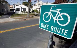
South of Wellington Street, vehicular traffic volumes are low enough to implement a signed cycle route, instead of painted cycle lanes.

On-Street Parking Changes

Designing safe cycling lanes on roads require changes to on-street parking.  There is not enough space on the road to accommodate both a cycling lane and on-street parking.


Parking will be prohibited on both sides of Lake Street between Placid Avenue and Wellington Street. No changes will be made south of Wellington Street.


The map below shows the current state of parking along the cycle route and the changes that will be made.

Changes to On-Street Parking

Download Technical Drawing

Lake St. Cycle Route Drawing (pdf)

Download

Click a Button Below to Learn About Other Bike Routes

Drop Us a Line!

This site is protected by reCAPTCHA and the Google Privacy Policy and Terms of Service apply.


City of Sault Ste. Marie - Planning & Enterprise Services


Powered by